PLace

al-Khunayzir

×

Error message

  • Unable to load CTools exportable Layer (ips_selectedvillageLayer).
  • Unable to load CTools exportable Layer (ips_villagemunicipalitylayer).
Place
al-Khunayzir — الخُنَيْزِير
Known also as: 'Arab al-Khunayzir
District
Galilee
Subdistrict
Baysan
Average Elevation
-200 m
Distance from Baysan
10 km
Population
Year Arab Total
1931 200
1944/45 260 260
Land Ownership (1944/45) in dunums
Year Arab Jewish Public Total
1944/45 1966 1000 141 3107
Land Use (1944/45) in dunums
Use Arab Jewish Public Total
Non-Cultivable & Built-up (Total)
Use Arab Public Total
Non-Cultivable 34 141 175
34 141 175 (6%)
Cultivable (Total)
Use Arab Jewish Total
Cereal 256 299 555
Plantation and Irrigable 1658 701 2359
Citrus and Bananas 18 18
1932 1000 2932 (94%)
Number of Houses (1931)
47

The village stood on flat terrain on the western edge of the village of al-Zarra'a, which diminished in size after the establishment of the Jewish colony of Tirat Tzvi in 1937. A secondary road linked it to the Baysan-Jericho highway, and other roads connected it to adjacent villages. AI-Khunayzir was initially a seasonal campsite for nomadic Bedouin who eventually settled there year round. Their dwellings, both adobe houses and tents, were dispersed over a wide area. All of the people of al-Khunayzir were Muslims. They drew water from springs north and southeast of the site for domestic use as well as for crop irrigation. They grew fruit, vegetables, and grain. In 1944/45 a total of 18 dunums was devoted to citrus and bananas and 256 dunums were allocated to cereals; 1,658 dunums were irrigated or used for orchards.
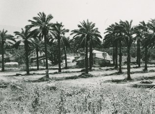
The settlement of Tirat Tzvi  was established on the lands of the villages of al-Khunayzir and al-Zarra'a in 1937.

The only remaining landmark is a cemetery on Tall Abu al-Faraj , north of the site. To the north and west of this tell are the springs of Uyun Umm al-Faraj and Ayn al-Khanazir. Most of the village site and the land around it are covered with palm trees.